The meteological component
Tide levels are also influenced by meteorological factors, the most relevant of which are variations in the atmospheric pressure and the wind.The atmospheric pressure is given by the strength performed by air masses on the Earth surface. Hence, its action also covers seas and oceans, squeezing them in relation to its intensity.Specifically, low pressure values are matched by higher values in the sea levels (inverted barometer effect). The effect of the wind is more complex and depends on its strength, direction and duration, as well as on the shape and reach of the basin on which it blows: the wind tends to squeeze waters towards its direction of propagation.The sum of these two physical phenomena is called “overise”, and leads to positive or negative increases as compared with normal astronomical oscillations.
The Adriatic basin, due to its narrow and long shape, is a semi-closed basin, and because of its low seabed, it favours the utmost exhalation of the tide in its Northern part (fig. 2).
The winds Sirocco (coming from the SE sectors) and Bora (coming from NNE) can lead to major overises in the Northern Adriatic.
The propagation of the tidal wave in the Adriatic occurs around the amphidromic point, where there is zero tidal amplitude. This point is located halfway between Ancona and Zadar (Croatian coast). When the tide enters the Otranto channel, it goes through the Adriatic sea anticlockwise with a speed of propagation of about 130 km/h. It first goes up the Balkan coast of Dalmatia in a South-North direction, laps Istria and carries on towards Trieste and Grado. Then, it turns in East-West direction towards Lignano, Venice and Chioggia, goes through the Italian coast towards Ancora, Vieste and Brindisi, and completes its cycle in Otranto, 12 hours and 24 minutes later, with the tide coming from the Ionian Sea.
This rotation, called “amphidromy”, derives from the composition of the effects of a longitudinal oscillation of the tide, with a transverse oscillation, developing in the sea as a consequence of the rotation of the Earth.Moreover, free oscillations – called seiches – develop within the Adriatic. This is how the sea reacts to the quick change in the meteorological forcing (wind and pressure). When the wind intensity suddenly decreases, periodic oscillations are generated, which tend to restore the hydrostatic equilibrium. The main seiches in the Adriatic have a period of about 21 hours and 11 hours.
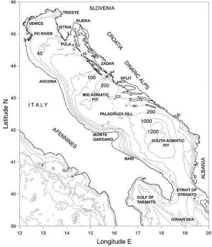 Fig.2 – Adriatic Basin
Tide propagation within the lagoon
The Venice lagoon communicates with the Adriatic Sea by means of three reinforced harbour inlets (Lido, Malamocco and Chioggia), and is also subject to the variations of the tide level, called “high water” when the populated areas of Venice, Burano and Chioggia are flooded. The historical areas are differently flooded according to the rise in local treading on the sea level. For example, the flooding of Saint Mark’s Square in Venice (photograph on the right), is higher than 80 cm as compared with the Zero Tide Level at Punta della Salute (Italian acronym: ZMPS), yet does not constitute an occurrence of “high water”, as the Square is not located in the lowest point of the city.
Moreover, the tidal wave is strongly slowed down when entering the lagoon and reaches the several locations within the lagoon with different delays. The tide height is lowered inside the lagoon, due to the friction caused by the low seabed and by the winding course of the innermost channels, bordered by salt marshes. The following table depicts the propagation delays of the astronomical tide, recorded by the main tide gauges of the Tide Gauge Network of the Venice Lagoon (Italian acronym: RMLV) when the tide enters the lagoon/Saint Mark’s basin.
Average delay of the tide in the several lagoon locations as compared with Saint Mark’s basin
| Station | Delay (min) | Station | Delay (min)
|
| Malamocco Diga Nord | -50 | Murano Colonna | 14 |
| Lido Diga Sud | -49 | Valgrande | 17 |
| Chioggia Diga Sud | -47 | Murano canale Angeli | 25 |
| Piattaforma "Acqua alta" | -47 | Campalto | 32 |
| Meda Bocca Lido | -38 | urano imbarcadero | 32 |
| Chioggia Vigo | -20 | Tagliata Vecchia | 32 |
| Faro Rocchetta | -19 | Petta de Bò | 34 |
| San Nicolò | -16 | Settemorti | 35 |
| Poveglia | -5 | Tessera | 39 |
| Ex Poveglia | -1 | Valle Averto | 40 |
| Sacca Sessola | 0 | Cason Figheri | 52 |
| Sant’Erasmo Capannone | 0 | Barene della Grisa | 53 |
| Brondolo | 1 | Val Fogolana | 59 |
| Motte di Volpego | 3 | Val Morosina | 1h 01’ |
| San Giorgio in Alga | 4 | Pagliaga | 1h 14' |
| Fusina | 4 | Le Saline | 1h 18’ |
| Marghera canale ind. Ovest | 9 | Canal Ancora | 1h 46’ |
| Torson di sotto | 12 | Grassabò | 2h 01’ |
| Botte Trezze | 14 | Cavallino | 2h 28’ |
Source: Ferla M., Cordella M., Michielli L., Rusconi A.,“Long-term variations on sea level and tidal regime in the lagoon of Venice", Estuarine, Coastal and Shelf Science 75 (2007) 214-222.The ability of the lagoon to resist the tidal wave can vary in time, as a consequence of morphological changes due both to natural causes, and to causes of manmade origin. Over the life of the Venice lagoon, human actions have been increasingly important in time. One of these was the historic diversion of several river beds (Brenta, Bacchiglione, Piave, Sile), which was performed to prevent the silting-up of the Lagoon and harbour inlets. The construction of the Murazzi was just as important, that is massive dams built by the Serenissima to strengthen and protect the coastlines. The most important measures were taken starting from the late 1800’s: the construction of the reinforced dams at the three harbour inlets (Lido, Malamocco and Chioggia), the construction of the commercial channels (Vittorio Emanuele and Canale dei Petroli) to favour the industrial area of Porto Marghera. Last, but not least, mobile barriers were built at the harbour inlets to protect the lagoon from high water occurrences (MoSE - Electro-Mechanical Experimental Module). These works led to the construction of a new artificial island within the Lido inlet, the strengthening of the existing dams, the construction of the jetty (crescent-shaped dams) to protect the inlet from the tidal waves coming from South-East, the digging and dredging of the harbour inlets so that they could house the mobile barriers. It should be mentioned that compensation works were performed more recently, including the construction of new artificial salt marshes, and the strengthening of the existing ones.
Moreover, commercial channels were excavated to support harbour operations of cargo ships.
The delicate balance of the lagoon ecosystem and of its inhabited areas is also influenced by such phenomena as: the wave motion caused by watercrafts, the erosion of the shoals and salt marshes, the loss of sediment in the lagoon.
The above changes have affected and can be seen in the different hydrodynamic systems of the lagoon. As an example, the propagation delays of the astronomical tide in the first half of the 20th century and in the early 21st century are depicted (figure 3). The delays are calculated as compared with the passage of the high tide in the sea, recorded at the harbour inlets. In the first half of the 20th century major delays in the propagation of the tidal wave were recorded both in the Northern and Southern lagoon (figure 3 - left). In the early 21st century, only the Northern lagoon was partially able to slow down the advance of the tidal wave. This ability seems to have been seriously damaged in the Southern part of the lagoon (figure 3).
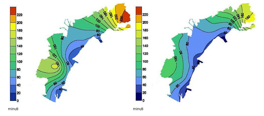 Figure 3 – Average delays of propagation of the tide within the Venice lagoon. First half of the 20th century (on the left), early 21st century (on the right). The delays are expressed in minutes as compared with the high tide at the harbour inlets.
Similar considerations can be made by comparing the height of the astronomical tide within the lagoon in the first half of the 20th century and in the early 21st century (figure 4). In the first half of the 20th century, the lagoon was absolutely able to lower the height of the tide, as it was entering it (figure on the left). This ability was lost in the early 21st century, with the only exception of the Northernmost lagoon (figure on the right).
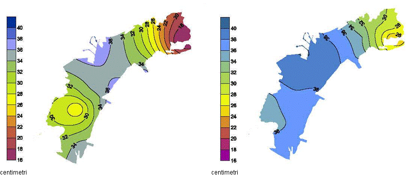
Figure 4 – Heights of the astronomical tide within the Venice lagoon. Lagoon in the first part of the 20th century (on the left) and in the early 21st century (on the right). The heights are expressed in centimetres. Mean sea level variation
The tide level has always been an integral part of the city of Venice and its lagoon. Ever since 1872, when systematic detections of the tide in the historical centre began, the tide has been monitored both in the short term – to forecast high water events – and in the long term.
The West coast of the North Adriatic features a natural phenomenon through which soils are compacted (subsidence). This phenomenon is more evident in the Po delta, which is a geologically very young area. In some instances human activities have greatly accelerated this phenomenon, especially when fluids were systematically tapped from the subsoil: the lesser pressure within the lower soil layers favoured their compaction, leading to a relative height loss as compared with the mean sea.The analysis of the annual variations of the mean sea level in Venice constitutes a good example of subsidence induced by human activities. Figure 5 depicts the growing mean sea, which - though this is a variable phenomenon - grew much faster between the 1940’s and 1960’s. This growth was probably due to the major groundwater drainage which took place in the Porto Marghera area for industrial purposes.
When the pits were closed in the early 1970’s the mean sea level stabilized.

Figure 5 – Variations of the annual mean sea level at Venice Punta Salute Eustasy, or else the increase in the mean sea level due to global warming, must also be taken into account. Considering the present rate of subsidence, in line with the forecast by the Intergovernmental Panel on Climate Change (IPCC), the local mean sea level is expected to increase by 2.8 to 6.9 mm/year over the next hundred years.
Zero tide level at Punta della Salute tide gauge
Systematic measurements of the sea level, as well as of the highest and lowest peaks of the tide started to be made in Venice in 1871, when an Engineer, Mr Tomaso Mati introduced the first tide gauge at palazzo Loredan in Campo Santo Stefano, at the headquarters of the Public Works Department. The above date marked the start of tide measurements through a scientific method, that is the introduction of a reference plane from which the tide heights recorded at specific times could be inferred. There are no quantitative data on the tide levels before 1871; only the chronicles are available - as of the 6th century - drawn up when high water events took place, and they provide qualitative information on the phenomenon. In 1888, the Military Geographical Institute introduced another tide gauge at the Venetian Arsenal and in 1906 the tide gauge station at Punta della Salute was installed in Saint Mark's Basin. At first it was placed on the Grand Canal, then in 1923 it was moved to its present location, on the Giudecca Canal. This station has become, by convention, the local point of reference for the city of Venice and the whole lagoon.
The first reference plane was the Comune Marino calculated for the year 1825, defined as the mean level of the high tides, coinciding with the “line of the green” made up by the algae found on the walls of the buildings and on the fondamenta (roads parallel to canals). This level was marked on the walls of some buildings by carving a horizontal line and the letter C. The zero was then set at 1.50 m below the Comune Marino, in order not to deal with negative numeric values.
Later, the Tide Gauge Zero at Punta della Salute (ZMPS) was chosen as a reference plane, equal to the mean sea level in 1897, calculated by averaging the observations carried out over 25 years, from 1885 to 1909, and setting the central year as a reference value. If compared with the altimetric network of the Italian State, which refers to the mean sea level recorded by the Genoa tide gauge in 1942 (averaging the data recorded from 1937 to 1946), the ZMPS is about 23 cm lower.
The introduction on the ZMPS made this reference connected to the Venetian soil, so that high waters featuring the same height, which took place at different times could be compared. In such cases the same percentage of flooding should occur in the city of Venice.
The historical tables of the tide in Venice
Knowing the level of the astronomical tide has always been fundamental for navigation, as well as to forecast the actual tide. Ever since the early 60’s the annual dossier on tide forecasting has been drawn up in two parts. The first section introduces and describes the phenomenon, and the second section includes the astronomical tide curves for Saint Mark’s Basin and the current speeds at the canal-harbour in the Lido. Thanks to research carried out in the files, the astronomical tide curves forecast ever since the 1920’s were found. To forecast the astronomical tide, it must be broken down to harmonic components. The different components are summed up at a pre-set time
ti, then the average reference level
A0 is added. Eight of the above components are enough to precisely calculate the astronomical tide in Venice and in the Adriatic. As mentioned earlier on, due to the unique nature of the territory and of the global phenomena occurring in Venice and its lagoon, the average reference level has greatly changed over time. Through the recovered historical tables of the tide, the average level
A0 adjustment from 1872 to date was accurately retraced. A detailed depiction of the topic is to be found in the Atti dell'Istituto Veneto di Scienze Lettere e Arti, Tomo CLXIX (2010-2011) - classe di scienze fisiche, matematiche e naturali, available in the section
Ricerche, area Pubblicazioni.
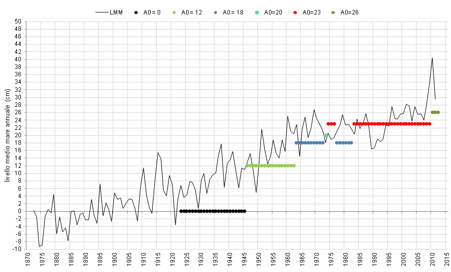
Figure 6 - Variations of the reference levels A0 compared with the mean sea level in Venice