Scelta lingua:


Istituto Superiore per la Protezione
e la Ricerca Ambientale
Istituto Superiore per la Protezione
e la Ricerca Ambientale


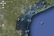
The Unit for Tides and Lagoons manages a network of 45 tide gauge stations equipped for the systematic measurement of water level and other related parameters, such as wind direction, wind speed, atmospheric pressure, precipitation, and wave-height into the Lagoon of Venice and in the north-western Adriatic coastline.
The greater part of the 45 tide gauge stations have been operating for several decades and therefore, the Unit for Tides and Lagoons manages time series of tide data lasting more than 145 years.
Each of these stations is equipped with modern tool that gauges and records the tide level electronically according to the protocols set by international scientific organization (WMO – IOC).
Of these 45 tide gauge stations, 25 have been operating for more than 20 Years with real time data transmission to the processing centre of the Unit for Tides and Lagoons. Correct functioning of this system is fundamental for warning and predicting of exceptional or atypical high tides (storm surges) and the management of the hydraulic system.
Tide gauge station of Punta della Salute has been also equipped with a co-located suitable GPS in order to detect the continuous vertical shifts of the local Zero Tide Level which is the reference benchmark for tide measurements in the Lagoon of Venice.
The 45 tide gauge stations, the data processing centres and the radio relay network constitute the Real Time tidal gauge system of the Lagoon of Venice. This system is a fundamental part of the weather and marine monitoring system of the Italian seas, controlled by ISPRA, including the National tide gauge Network and National sea Waves measuring network. In addition, the Unit for Tides and Lagoons has the capability to exchange data measured in real time between the networks of the environmental operating centres of the north-Eastern Regions of Italy (Veneto and Friuli Venezia Giulia) and Civil Defence.
The real-time operability of this network is aimed at several purposes among which are: analysis and elaboration of data referring in particular to extreme events (storm surges), signalling and forecasting exceptional high tides.
Moreover, the Real Time tidal gauge Venice Lagoon Network is an important source for both planning and scientific studies such as the sea level variations and Venice defence from the phenomena of high tides.
Istituto Superiore per la Protezione e la Ricerca Ambientale (I.S.P.R.A.)
Centro Nazionale per la caratterizzazione ambientale e la protezione della fascia costiera, la climatologia marina e l'oceanografia operativa
Indirizzo:
Calle larga dell'Ascension San Marco, 1260
30124 Venezia (VE)
Email: venezia@isprambiente.it
Indirizzo:
Via Vitaliano Brancati, 48 - 00144 Roma
Centralino: (+39) 06 50071
Fax: (+39) 06 5007291
Telefono: (+39) 06 50074832
Fax: (+39) 06 50072916
Email: urp@isprambiente.it